


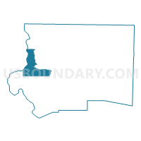
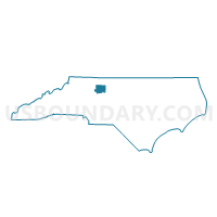
Voting District 133, Forsyth County, North Carolina
About
Outline

Summary
| Unique Area Identifier | 640103 |
| Name | Voting District 133 |
| County | Forsyth County |
| State | North Carolina |
| Area (square miles) | 14.46 |
| Land Area (square miles) | 14.13 |
| Water Area (square miles) | 0.34 |
| % of Land Area | 97.67 |
| % of Water Area | 2.33 |
| Latitude of the Internal Point | 36.12253810 |
| Longtitude of the Internal Point | -80.42904590 |
Maps

Graphs
Select a template below for downloading or customizing gragh for Voting District 133, Forsyth County, North Carolina


Neighbors
Neighoring Voting District (by Name) Neighboring Voting District on the Map
- Voting District 074, Forsyth County, NC
- Voting District 075, Forsyth County, NC
- Voting District 091, Forsyth County, NC
- Voting District 131, Forsyth County, NC
- Voting District 132, Forsyth County, NC
- Voting District 809, Forsyth County, NC
- Voting District 906, Forsyth County, NC
- Voting District EBND, Yadkin County, NC
- Voting District FBSH, Yadkin County, NC
Top 10 Neighboring County Subdivision (by Population) Neighboring County Subdivision on the Map
- Winston township, Forsyth County, NC (229,617)
- Lewisville township, Forsyth County, NC (17,707)
- Vienna township, Forsyth County, NC (10,243)
- Old Richmond township, Forsyth County, NC (5,236)
- Forbush township, Yadkin County, NC (4,032)
- East Bend township, Yadkin County, NC (3,489)
Top 10 Neighboring Place (by Population) Neighboring Place on the Map
Top 10 Neighboring Unified School District (by Population) Neighboring Unified School District on the Map
Top 10 Neighboring State Legislative District Lower Chamber (by Population) Neighboring State Legislative District Lower Chamber on the Map
- State House District 75, NC (82,603)
- State House District 92, NC (68,165)
- State House District 74, NC (67,946)
Top 10 Neighboring State Legislative District Upper Chamber (by Population) Neighboring State Legislative District Upper Chamber on the Map
Top 10 Neighboring 111th Congressional District (by Population) Neighboring 111th Congressional District on the Map
Top 10 Neighboring Census Tract (by Population) Neighboring Census Tract on the Map
- Census Tract 26.03, Forsyth County, NC (6,553)
- Census Tract 501.01, Yadkin County, NC (5,600)
- Census Tract 40.09, Forsyth County, NC (3,802)
- Census Tract 41.03, Forsyth County, NC (3,478)
- Census Tract 40.10, Forsyth County, NC (3,392)
- Census Tract 41.02, Forsyth County, NC (3,256)
- Census Tract 39.08, Forsyth County, NC (3,085)
Top 10 Neighboring 5-Digit ZIP Code Tabulation Area (by Population) Neighboring 5-Digit ZIP Code Tabulation Area on the Map
- 27106, NC (45,015)
- 27104, NC (28,485)
- 27023, NC (11,873)
- 27040, NC (10,893)
- 27018, NC (7,655)
- 27050, NC (3,893)